Introduction: The Living Map
America is not a completed project. It is a geography still fighting to define itself, a wild, restless blueprint caught in an endless argument between creation and destruction. To travel across this land is to witness a planet caught in the act of reinventing itself, shaping borders with a fierce, eternal struggle between fire, ice, water, and wind. The map we know is merely a temporary suggestion.
I: The Volcanic Forge of the Pacific
Life here begins in the Pacific, on the dripping, emerald slopes of Kauai. Rain falls in heavy, relentless sheets across Mount Waialeale, gathering in the summit’s clouds to pour almost without pause. It descends in countless silver threads, merging into a weeping veil of water over sheer cliffs. But that serene, waterlogged beauty is an illusion of permanence. Just islands away, the ground literally tears itself open to burn.
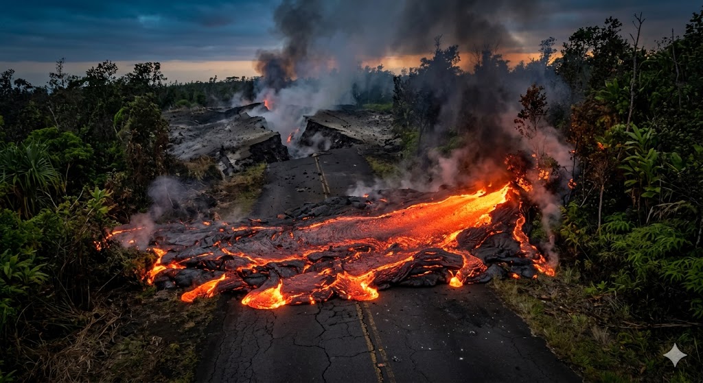
On the Big Island, Kilauea erupts with a blind fury, its lava reaching nearly 2,000°F as it casually swallows forests, roads, and entire neighborhoods. This is the raw engine of creation. As the old earth is incinerated, new shorelines are born, cooling into sharp, blackened glass. The scale of this construction is difficult to fathom until you look at Mauna Loa. Rising more than 13,000 feet above the ocean’s surface, its true mass stretches nearly 30,000 feet down to the seafloor, making it Earth’s largest volcano by volume. Over the past 700,000 years, it has violently erupted over 30 times, methodically pouring a new foundation for the continent.
When the lava finally cools, the elements take over. Time begins a slow, quiet conversation with the hardened rock, replacing volcanic violence with the patience of water. On Maui, the Nakalele blowhole exhales thick ocean spray in rhythmic bursts, as if the island is still breathing through its ancient lungs. In the calm, turquoise shallows offshore, humpback whales gather to birth their young in the warm Pacific waters. Calves practice breaching, building the muscle required for the grueling migration north, while the haunting, low-frequency songs of males echo across the miles below.
II: The Tyranny and Architecture of Ice
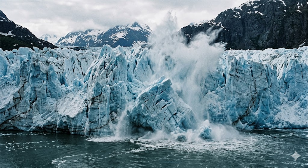
Where the fire abruptly stops, ice takes absolute command. In the far north, heat yields to the crushing pressure of frozen gravity. Just two and a half centuries ago, Alaska’s Glacier Bay was a solid, wall-to-wall block of ice. Today, you can stand on the deck of a boat and watch tidewater glaciers collapse into the sea without warning, releasing kinetic energy equivalent to small earthquakes. In America, mountains of ice disappear within a single human lifetime.
But the ghosts of ancient glaciers haunt the lower forty-eight, too. The razor-sharp ridges of Montana’s Glacier National Park reveal the profound, brutal handiwork of the last ice age. Over 700 miles of deeply sculpted valleys and tarn lakes define a terrain that was once crushed beneath an entire mile of solid ice. The high limestone cliffs here expose the fossils of ancient seas dating back more than 1.5 billion years, offering one of the planet’s longest uninterrupted geological records.
Life in this vertical, frozen world demands extreme specialization. High on the ledges, mountain goats navigate sheer rock faces as steep as 60 degrees, their rubberized hooves gripping stone polished smooth by centuries of freeze and thaw. Wrapped in dense, double-layered coats, they shrug off wind chills that plummet below -50°F. They turn a grueling 1,500-vertical-foot ascent into a casual twenty-minute stroll, retreating to windswept ridges above 10,000 feet where no predator dares to follow.
III: The Scorch and Stone of the Southwest
Drop in elevation, and the pristine white of the alpine fades into violent, burning hues of orange and vermilion. The American desert is an open archive, recording the planet’s fire in stacked layers of sandstone.
In Utah’s Zion National Park, you walk through the fossilized remains of vast sand seas that drifted across the supercontinent Pangea over 150 million years ago. Iron and manganese oxidized deeply within the sand grains, bleeding into the rock to give the cliffs their dramatic red tones. The Virgin River still slices through this petrified desert, cutting canyons over 2,000 feet deep.
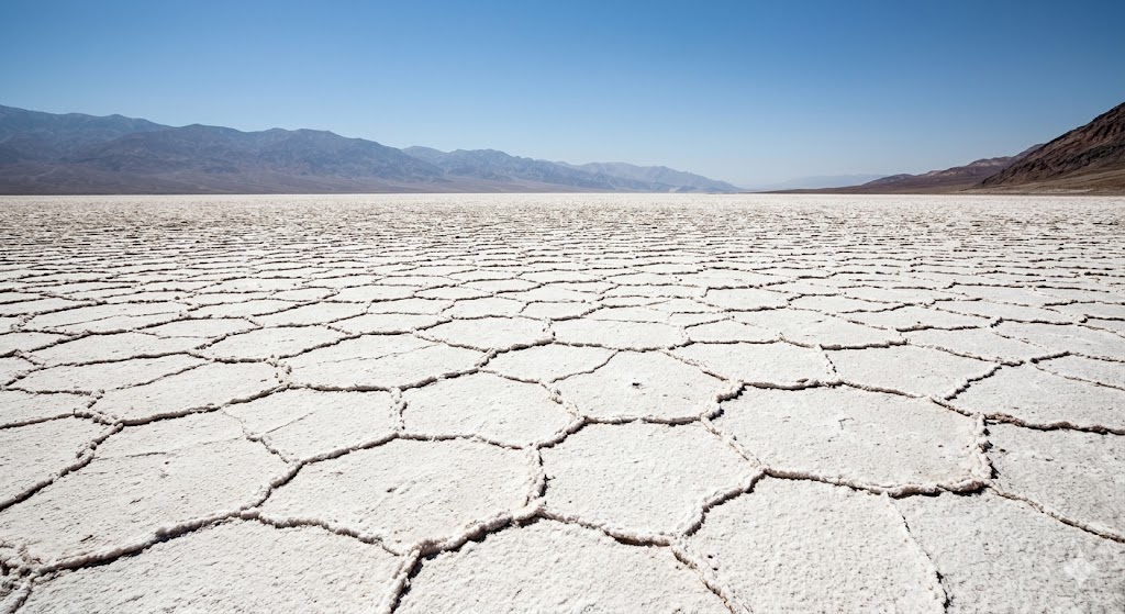
Nothing prepares you for the sheer hostility of Death Valley. Sinking 282 feet below sea level, Badwater Basin is floored with a crust of hexagonal salt plates left behind by a vanished Pleistocene lake. Step out of your vehicle in the summer, and the heat hits you like a physical wall, screaming past 130°F. The ground temperatures can easily exceed 200°F, completely vaporizing the rare rainfall before it even has a chance to soak a single inch into the dirt. Yet, this unforgiving basin occasionally orchestrates a miracle. When the right winter storms arrive, over a thousand species of dormant wildflower seeds awaken in a synchronized explosion of color, proving that life here is deeply patient.
Further south, the earth drops away into a gorge so vast it completely rewrites the human understanding of scale. The Grand Canyon runs 277 miles long and plunges up to 6,000 feet deep into the crust. The Colorado River erodes the rock at a painfully slow rate—about the thickness of a sheet of paper each year—but that relentless patience has exposed nearly two billion years of geological history, down to the ancient Vishnu Schist at the canyon’s floor.
IV: Subterranean Vaults and the Forest of Giants
America’s beauty isn’t confined to the sky. Beneath the driest deserts, hidden systems wait in the dark. Inside Great Basin National Park, Lehman Caves stretch for over two miles through marble that was once buried under a prehistoric sea. Acidic groundwater painstakingly sculpted these corridors, where delicate calcite shields hang like fossilized ripples and stalactites grow a mere millimeter every century.
In New Mexico, the underground world expands into the incomprehensible. Carlsbad Caverns National Park holds over a hundred known caves, formed millions of years ago when sulfuric acid dissolved a massive Permian reef. The cavern’s “Big Room” spans a staggering 4,000 feet in length and reaches 255 feet high, a subterranean cathedral where colonies exceeding 400,000 bats roost in the suffocating darkness.
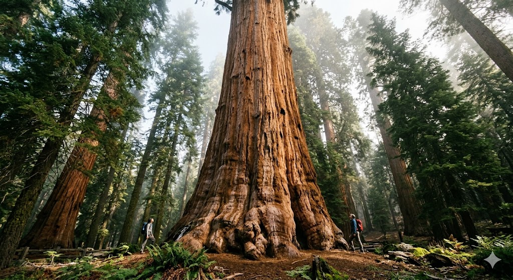
Above ground, in California’s Sierra Nevada, you find living monuments born of fire and ice. Yosemite Valley’s El Capitan rises 3,000 feet vertically, dominating the skyline as the largest single granite monolith on Earth, carved over 2.5 million years by retreating glaciers. Not far away, the ancient sentinels of Sequoia National Park stretch 275 feet into the air with trunks over 30 feet in diameter. The General Sherman tree, anchoring the forest at an estimated 2,200 years old, holds the title of the largest single tree by volume on the planet. Packed with chemical tannins, their thick bark repels insects and insulates against the fierce heat of wildfires. Here, fire isn’t a destroyer; it is a required catalyst, clearing the brush so new giants can take root.
V: The Pulse of Water and the Great Migrations
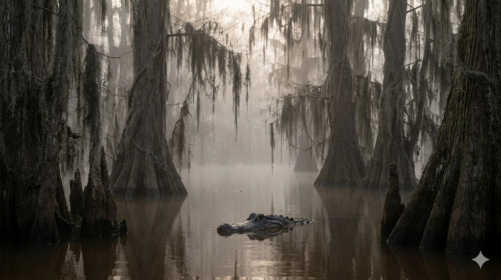
Where water pools, life organizes rapidly around it. In the deep South, the landscape trades the stark openness of the desert for dense, suffocating constraint. The Atchafalaya Basin in Louisiana is the largest river swamp in the United States, a million-acre labyrinth of cypress and tupelo forest heavily fed by the nutrient-rich silt of the flooding Mississippi.
This murky world is entirely dominated by the American alligator. Reaching lengths of 13 feet and weighing over 800 pounds, these apex predators act as vital ecosystem engineers. They excavate deep “gator holes” that retain precious water through the brutal dry seasons, sustaining trapped fish, turtles, and birds until the rains return.
Further east, the Everglades span 1.5 million acres of sawgrass marsh and mangrove wetlands. Here, water moves south from Lake Okeechobee toward Florida Bay at the agonizing pace of a slow walk, averaging less than a foot deep. It is a painfully fragile ecosystem, entirely dependent on seasonal flooding, where the loss of just a few inches of water threatens an entire biological chain.
This abundant water sustains nature’s oldest form of memory: migration. Millions of migratory birds navigate the massive Mississippi and Pacific flyways, using coastal wetlands as critical refueling stops on journeys spanning up to 9,000 miles between hemispheres. Guided by magnetic fields and celestial cues, they arrive in perfect sync with seasonal insect hatches, a delicate biological ballet written long before human maps. On the West Coast, impossibly fragile monarch butterflies, each weighing less than a paperclip, travel up to 3,000 miles to gather by the tens of thousands in California’s coastal groves, relying on a deeply embedded magnetic sense we are only just beginning to decode.
VI: The Human Imprint and Cities of Stone

Civilization in America did not conquer the landscape; it merely imitated it, building settlements wherever the terrain demanded adaptation. Coastlines, river deltas, and fault lines fundamentally dictated the geometry of human expansion.
The grandest American cities explicitly mirror their underlying geology:
New York City: The densest concentration of skyscrapers on Earth rises precisely where the subterranean bedrock schist provides the strength to hold them.
San Francisco: Famously balancing its grid across 43 steep hills heavily warped by the grinding tension of the San Andreas Fault. Its Golden Gate Bridge spans the violent, shifting currents of the bay, rooted 110 feet deep in massive concrete caissons.
Chicago: Transformed utter disaster into architectural innovation. After the Great Fire of 1871 leveled the city, engineers invented the steel-frame skyscraper, driving deep timber piles into the earth to lift the metropolis vertically. They even reversed the flow of the Chicago River to safeguard the city’s freshwater supply.
Down on the humid, tidal coast of South Carolina, Charleston’s elegant, pastel Georgian homes stand on thick cypress pilings sunk deep into the marine clay, sitting barely six feet above the swelling tide. New seawalls and floodgates aren’t built in arrogance, but in a quiet acknowledgment of the original design intent: coexistence, rather than defiance, with the ocean. And in St. Augustine, Florida, the oldest European settlement in the continental United States survives because of the earth itself. Its 17th-century fortress, the Castillo de San Marcos, was constructed from coquina limestone—a porous aggregate of crushed shells that miraculously absorbed enemy cannon fire instead of shattering.
Conclusion: A Blueprint Still Being Drawn
America is a land where structure, tension, and endurance are written directly into the rock. The ice grinds, the rivers cut, and the fault lines quietly accumulate strain beneath our feet. Every canyon, every monument, and every glittering skyline remains strictly temporary within the massive, uncaring scale of geological time. We are simply living on a blueprint that the earth is still actively drawing.